1. What is the relationship between rainfall and flooding?
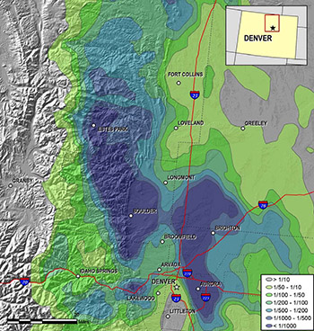 Immediately after the flood, a NOAA press release referred to this as a 1000-year rainfall event, based on NOAA-Atlas 14. In our WWA flood briefing, we pointed out that there are large error bars associated with such estimates on a regional scale. On the other hand, Boulder proper apparently “only” experienced a 25-to-50-year flood, according to Gilbert White’s famous marker along Boulder Creek. It would be worthwhile to figure out to what extent this discrepancy is due to a difference in methodology between NOAA (rainfall distribution fits) and USGS (flooding assessments), since the media (and general public) tend to conflate rainfall and flooding extremes. Since there have been at least five 10”+ rainfall events along the Front Range in the last five decades (Denver 1965, Jamestown 1969, Big Thompson 1976, Fort Collins 1997, and Boulder 2013), NOAA-Atlas 14 may need a revision in this region. And this is without even bringing in the specter of climate change that may alter future rainfall probabilities towards the more extreme end.
Map: Annual exceedance probabilities for the worst case 7-day rainfall. Credit: NOAA’s National Weather Service, Hydrometeorological Design Studies Center.
2. How important were recent wildfires in exacerbating flooding impacts?
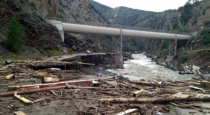
It is noteworthy that one of the flood victims (Joseph Howlett, Jamestown) was killed by a rock slide that originated from a fire scar above town that dates back to an October 2003 wildfire (almost 10 years before the flood). Other slides were common right across the hillsides of Boulder County, including the Four Mile burn area from a much more recent fire (September 2010). While it is possible that most of the landslides would have happened in the absence of fire scars, it would be a useful exercise to match such fire scars with landslides to see how much of an increased risk there really was, with and without mitigation efforts.
3. Did flood control measures in Boulder and elsewhere work?
Before congratulating ourselves in Boulder on the relatively mild flooding impacts, a detailed rainfall analysis might reveal that there was a dramatic dropoff in rainfall in the upper reaches of Boulder Creek – while Boulder received more than 17” during that fateful week in September, Nederland did not even get half as much. Just 10-20 miles to the north, communities from Jamestown to Allenspark recorded around 15” at similar elevations, so Boulder Creek could have been hit much harder (as was the case along the St. Vrain or Big Thompson rivers). Having a flooding event in September is also well-timed, since most reservoirs are typically near their annual low point, especially after a dry summer on the eastern plains that increased irrigation demand. To the delight of Front Range water managers, Barker and Gross reservoirs were among many reservoirs that ended up getting completely filled at a very unusual time of year, holding back critical runoff that might have made the flooding situation much worse. Getting back to the original question, it is important to know which mitigation measures implemented over recent decades in Boulder did their job, and which ones did not. In that context, I would not be surprised if the 100-year flood plain maps may also need to be revisited.
4. What can we learn from this flood that will reduce the impact of the next one?
While it may be tempting for affected parties to try to rebuild everything the way it was, it would be worthwhile to assess the current damages in the context of the 1969 and 1976 floods in particular, since the 2013 flood encompassed them both. Governor Hickenlooper admitted to this in the context of rebuilding the Big Thompson State Highway 34. After the 1976 flood, homes with more than 50% flood damage were apparently not allowed to be rebuilt, to the dismay of affected homeowners, since that might have been without precedent in Colorado. After the 2013 flood, it would be interesting to assess how many ‘virtual’ homes and lives were spared this time around because the state of Colorado had learned a lesson.


 Klaus Wolter