

 |
 |
 |
 |
notes from the field
These field notes are personal views and do not necessarily reflect the views of Red Cross/Red Crescent Climate Centre
Sierra Gladfelter
Zambia
June 3 - August 23, 2016
Anticipating Disaster: Formal Climate Information vs. Traditional Ways of Knowing Floods and Droughts
August 2016
View photo gallery for more photos from the field by Sierra Gladfelter
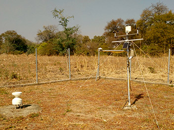
 Rural Zambian communities living on the floodplains of the Zambezi River are increasingly suffering from climate-induced disasters, with both floods and droughts alternatively striking and eroding their security. In Kazungula, an underdeveloped district located in the Southern Province upstream from Victoria Falls where the Zambia Red Cross Society (ZRCS) is currently supporting interventions, residents receive limited support in anticipating such disasters. While the Zambia Meteorological Department (ZMD) prepares and disseminates forecasts as part of its mandate to provide advisory services, the kind of data it is able to provide in terms of resolution and time scale is limited. Currently the ZMD distributes three types of forecasts including six-month seasonal forecasts with detailed information on how weather and climatic patterns like El Niño and La Niña will influence rainfall over the region, as well as 10-day and daily forecasts. This information, formulated at the national level and downscaled for each province, is disseminated by email to key stakeholders such as ZRCS Disaster management staff, agriculture extension officers, local government officials and individuals who formally request to be added to the department’s list. This is the same mechanism through which people would be warned in the event of an impending disaster.
In a country where much of the rural population lives isolated even from radio and cell phone service, however, the impact of electronically distributed forecasts and advisories provided by the ZMD is constrained. The data that makes it to the ground is primarily limited to seasonal forecasts which are printed on pamphlets and distributed annually by ZMD. On a short term basis, however, the burden of dissemination to local communities falls onto the shoulders of the nation’s agriculture extension officers employed by the Ministry of Agriculture and Livestock in each district. These individuals serve as the primary intermediaries between the ZMD and rural farmers in both providing and translating weather and climate information for local decision-making. While communities are primarily able to access this information at frequent village meetings, agriculture extension officers also have their own constraints and are often forced to provide services without reliable communication or transportation. For example, one agriculture extension officer whom I interviewed in Kazungula had not had a functional motorbike in a year and was only able to access the more remote communities by coordinating transport with other NGOs working in the area. These communication and logistical challenges mean that although ZMD regularly produces useful information to disseminate, even 10-day forecasts rarely reach rural Zambians while their content is still timely. Thus, the ZMD’s seasonal forecasts are currently the closest thing to a formal ‘early warning’ provided to communities in advance to floods and droughts.
"Knowing in advance that floods and droughts are predicted certainly does enable rural Zambians to take some precautionary measures. Most residents that I interviewed whose livelihoods depend on rain fed agriculture, described the utility of the ZMD’s seasonal forecasts for determining crop types and adjusting the timing of their planting. For example, if a drought is predicted farmers will plant drought-resistant varieties or traditional crops like sorghum that can handle a limited amount of water. In the case of flooding or excessive precipitation, people choose late maturing crop varieties. However, at the broad timescale of a seasonal forecast, the kind of actions that people can take without any actual lead time prior to a disaster, are severely limited." |
For this reason, Zambians living in communities in Kazungula depend equally, if not more, on traditional mechanisms for predicting floods and droughts.
 In interviews and focus groups with rural farmers living in the communities of Sikaunzwe, Kawewa, and Kasaya, community members described the most common indicators embedded in the landscape that they have historically relied on and continue to rely on to anticipate floods and droughts. By far the most common response I was given from nearly everyone I interviewed, was the significance of cobwebs suspended in the atmosphere as a portent for impending floods. Although the precise details of how these cobwebs emerge and the timing until a flood occurs remains unclear, informants consistently cited the presence of these nets of whitish silk that hover in the atmosphere as one of the surest signs of inundation. Similar phenomena of spiders escaping floodwaters on winds have been documented in places as diverse as Australia and Pakistan. Here in Zambia, when the webs are transported on northwest winds coming from upstream and settle onto trees in the bush, people can reliably expect floods in a short time. In fact, several people were so confident that every time they see these webs they will get flooded, that this sign alone is cause for relocation to the uplands. One informant who had lost his home and 39 animals in the devastating 2006 flood, said that he had seen the cobwebs prior to that event and so when he saw them again in 2008 took early action to prevent more loss. Sure enough, by February another devastating flood had struck the region.
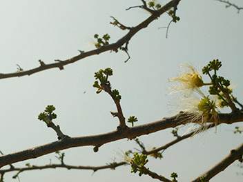
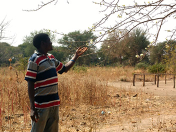
In addition to the cobwebs that balloon over the bush prior to floods, residents pay close attention to the movement of birds, especially swallows or tumbeambe. When seen in large numbers moving in unison, residents know that heavy rains are on their way. Moreover, the flowering of specific trees are used to anticipate the nature of the approaching season. Repeatedly during conversations, people pointed to the mango trees above our heads which were already flowering profusely in July. This, people assured me, meant there would be “enough rains” this year. (I have learned that here, “enough rains” means no drought, but likely floods. There always seems to be one if not the other.). Individuals also reference the fruit of the baobab tree as environmental indicator of rainfall; if its fruit is profuse, one can expect drought. If it is sparse, there will be significant rain. The deeper I got into these questions, and as I struggled to write numerous indigenous names of trees and plants—masuka, munga—the more it became obvious that there were signs of climate conditions everywhere embedded in the landscape, if one knew where to look.
“Everything is telling us that there will be rain this year,” one focus group participant in Sikaunzwe expressed. Such certainty exists even without the seasonal forecast from the ZMD. Local signs in nature are the primary guides for local adaptive action. Based on what they observe in the landscape, people make decisions about when to protect their fields with earthen ridges, reinforce their homes, move their cattle to the upland, or relocate out of the floodplain.
When I asked Kazungula residents which way of knowing they trust and rely on most, formal data or local environmental indicators, I received mixed responses. Over all, most people valued having access to government forecasts, but approached them with varying degrees of skepticism. It was only in Kasaya, however, that people were on the verge of losing faith in formal data, after the ZMD forecast for the previous season indicated good rains that never came. Since people had wholeheartedly embraced the forecast despite contrary indicators in the landscape, they had lost certain crops. This year, I was told, people would rely on their own methods if their local predictions contradicted the ZMD’s forecasts. Significantly, even of the individuals who asserted that ZMD forecasts were essential to their decision-making, no one I interviewed had fully abandoned or lost traditional ways of anticipating climatic conditions. Rather, they seemed to find the greatest value in supplementing their indigenous ways of knowing with improved scientific climate data.
"In the end, it is important to acknowledge that while both traditional knowledge and modern forecasts each have their role in disaster preparedness and in building climate resilience, for many local communities there is not the luxury of using both in tandem." |
 Without access to improved forecasts and climate information, the most vulnerable and remote residents are often left only with the knowledge they have been relying on for generations. While in many cases this may be effective, and deserves to be deeply respected, it should also not be romanticized. After all, as community members repeatedly expressed, while traditional knowledge continues to be their most reliable source of information, many still feel that their ability to use environmental indicators to anticipate floods and droughts is becoming more and more difficult with climate change. Farmers in Kazungula, like anyone, ultimately desire the best information available to secure themselves and their property from disaster. Thus, hybrid forms of knowledge that synthesize information from diverse sources—including both radar and cobwebs—will best support adaptation and ensure survival in the face of climate change.
Fortunately, in Kazungula, this is a reality recognized not only by residents, but also by the local agriculture extension officer, Mr. Kauwo. Although responsible for disseminating weather and climate data from the ZMD to communities, Mr. Kauwo also sees profound value in the place-based knowledge residents continue to rely on. “Those of us at grassroots level, who work directly with farmers see the value in this,” he explained. Therefore, when he holds meetings to disseminate the ZMD’s seasonal forecasts, he also asks villagers to share how they expect the season to be based on local environmental indicators. Together Mr. Kauwo and community members analyze to what extent the multiple sources of information match or provide contradictory evidence.
"While all decisions made in the increasingly precarious conditions of climate change will have some degree of uncertainty, it is in the spaces where multiple ways of knowing overlap and come together that we may have the most confidence in our actions." |