Roger A. Pielke, Jr.
Applied Behavioral Science Review, 1999: 7(2), 83-101.
O. A. Olson2
In April 1997, communities along the Red River of the North, which flows north along the North Dakota-Minnesota border, experienced extreme flooding. Damages related to the event have been estimated at $1-2 billion, with most occurring in Grand Forks, ND and East Grand Forks, MN.3 Almost immediately after the flood, residents and policy makers in Grand Forks and East Grand Forks began to point fingers at the river stage predictions issued by the National Weather Service (NWS) as a factor contributing to the disaster.4 At East Grand Forks, the Red River crested on April 22 at 54.11 feet, about five feet higher than the NWS had predicted up to April 14. In the days that followed, Lynn Stauss, mayor of East Grand Forks commented that "They [NWS] missed it, and they not only missed it, they blew it big" (Foster 1997).
This paper focuses on the role of river stage predictions in decision-making processes leading up to the inundation of Grand Forks and East Grand Forks. Interviews on which this research is based were conducted by the author as part of the National Weather Service (NWS) Survey Assessment Team which evaluated the agency's performance leading up to and during the flood (NWS 1998). The author served as an independent (i.e., non-governmental) member of the team. Such teams typically include one social scientist in their membership. The findings reported in this paper are those of the author, and should not be misconstrued as the official position of the Survey Team or any other organization or group with whom the author is associated. (The NWS assessment is available on the web at tgsv5.nws.noaa.gov/oh/Dis_Svy/RedR_Apr97/index.html).
The paper proceeds in six parts. Part II reviews current understanding of the flood problem faced by the United States. Part III describes spring 1997 flooding in the Red River of the North. Part IV assesses the role that river stage information played in flood-related decision making during the event. Part V introduces relevant experience that might allow for a broader understanding of the 1997 flooding. The paper concludes with the lessons of the Grand Forks experience for future use of river stage predictions.
That the United States has a flood problem has been long recognized (White 1945). At the same time, it has also been recognized that the flood problem has escaped reliable definition. Prior to the 1900s, policy makers viewed floods as an engineering challenge -- one of building structures to hold back water. Late in the first half of this century this view of floods was expanded to include the possibility of human adjustments to floods. Engineering, it was learned, would not be the sole solution to the nation's flood problem, people would have to change their behavior as well. More recently, the definition has expanded in scope once again. The health and status of river ecosystems is now an integral part of many people's conceptions of the flood problem facing the United States.
Flood impacts of recent years provide some insight as to the magnitude of the national problem. From 1993 to 1996 the nation experienced more than $28 billion (1996 $) in losses and more than 300 people lost their lives to floods.5 Both economic and human losses have been increasing in the latter half of this century (Pielke 1999a). An assumption underlying national flood policy is that many of these losses are preventable, and society's vulnerability to floods can be limited (FIFMTF 1994).
In order to reduce their vulnerability, communities in floodplains have developed a wide range of responses. When flooding is so extreme that a local community cannot effectively respond, then state, regional, and national agencies and organizations are called upon. This system of "shared governance" is characteristic of responses to floods, and to disasters more generally (May 1985). An important aspect of national flood policy is to correct those policy failures identified in the aftermath of a disaster. But typically there is a strong desire to "return to normal," making change difficult (Nilson 1985). In many cases "normal" refers to those same conditions that led to the disaster in the first place.
In the 1980s and 1990s considerable effort in a range of academic disciplines has been devoted to understanding the dynamics of response to natural disasters. A partial list of research topics includes intergovernmental performance (e.g., Schneider 1990), intergovernmental relations (e.g., Rubin and Barbee 1985), public policy aspects of disasters (e.g., Olson and Nilson 1982), education and public action (e.g., Sims and Baumann 1983), forecast improvements (Zevin 1994), land-use planning (e.g., Cigler et al. 1987), research evaluation (White 1994), and post-disaster case studies (e.g., Changnon 1996).6 In 1975, White and Hass published a review of contemporary research in natural hazards, focused on the disciplines of sociology and geography. A second assessment of natural hazards research has recently been completed, overseen by the Natural Hazards Research and Applications Information Center at the University of Colorado and an international assessment is underway under the auspices of the International Decade for Natural Disaster Reduction.7 These assessments provide a comprehensive resource on the literature of responses to floods in the United States and beyond.
The knowledge developed by natural hazards scholars is complemented by national policy assessments of the national flood problem, including the Committee on Public Works (1959), Unified National Program reports (TFFFCP 1966, USWRC 1976 and 1979, ITFFM 1986, FIFMTF 1994), and the comprehensive Floodplain Management Assessment (FIFMTF 1992). Yet in spite of all of this knowledge, it seems, as one observer has noted, "thoughtful past recommendations of how to attain flood mitigation had never been adequately implemented" (Changnon 1996, 312). Because of the recent spate of flood impacts, a window of opportunity might be open to apply the knowledge that has been gained to improve flood policy making in specific contexts (Solecki and Michaels 1994, Snare 1995). The experiences in the Red River of the North in 1997 could motivate opportunities for constructive policy change.
The Red River of the North basin is located in North Dakota and Minnesota in the United States, and in southern Manitoba, Canada (Figure 1). The Red River of the North flows north through Winnipeg, Manitoba, and is a tributary of the Nelson River basin, which carries runoff into Hudson Bay from much of southern Canada from the Great Lakes to the Continental Divide. Because of its extremely low relief, the region is prone to flooding.
Spring flooding in the basin is typically the result of snowmelt, which begins in the south, with melt-water flowing north. When portions of the river farther north remain frozen while the southern part melts, the river and its tributaries rises beyond their banks and spread out across the region. Other factors play an important role in whether or not a heavy snowpack results in a flood including the timing and rate of melting, additional precipitation, frost depth, soil moisture, and river ice conditions (Voelker 1997). For instance, the winter of 1993-1994 saw record snowfall (to that date) in the region but little flooding, while the winter of 1995-1996 saw less snowfall (fourth heaviest on record), but widespread flooding (Voelker 1997).
The winter of 1996-1997 broke records for snowfall throughout the region. The Grand Forks Herald popularized the practice of naming blizzards in a similar fashion to hurricanes (Grand Forks Herald 1997). In April 1997, blizzard "Hannah" brought to the region winds over 60 mph, and more than 20 inches of snow, the most severe blizzard since March, 1941 (Koelher 1997).8 The record snowfall set the stage for the record floods that were to follow.
Flooding began in the southern portion of the basin and proceeded north. First, during the weekend of April 4-6, Breckenridge, MN saw more than a quarter of its residents evacuated, and 500 buildings damaged (Grand Forks Herald 1997). Vice President Al Gore visited Breckenridge as President Clinton declared the region a federal disaster area. Nine days later water broke through the levees surrounding the city and then froze as temperatures dropped. To the north, Fargo, ND put up a tremendous flood fight and escaped major damage. The Fargo city engineer later commented "we spent a lot of money being lucky" (Grand Forks Herald 1997, 22). Dennis Walaker, Operations Manager for the City of Fargo, later commented that the city's "massive" preparations paid off: "the harder we worked, the luckier we got" (Walaker, 1998, personal communication, 11 September).
To the north of Fargo, the towns of Grand Forks, ND and East Grand Forks, MN lie on opposite sides of the river and had never been better prepared.9 Officials drew on lessons learned in 1979, when the Red River hit its highest point so far this century. There were detailed flood- fighting plans. Dikes were raised throughout the city. (Grand Forks Herald 1997, 24). As the river rose, residents worked frantically to save their homes and community. On April 18th, the dikes which protected the city began to give way. By early the next morning, all of East Grand Forks and about half of Grand Forks were inundated. That evening, a fire started in downtown Grand Forks, resulting in an eerie spectacle of disaster broadcast via the media across the nation. The eleven burned out buildings sitting in flood waters in the downtown area have come to symbolize the event.10
While towns to the north of Grand Forks, including Winnipeg, Manitoba, suffered some damages related to the floods, nothing came close to the tremendous destruction witnessed in Grand Forks and East Grand Forks. As the flood waters receded in the days that followed, the communities were faced with difficult decisions about how to recover and rebuild.
Because hydrologic floods are commonplace and unavoidable in the flat Red River basin, communities rely on flood forecasts issued by the federal government as an integral part of their flood decision processes.11 The forecasts are used in deciding how and when (and sometimes if) to fight the flood (Fought 1997). In the aftermath of the 1997 flooding in Grand Forks, public officials and other members of the community placed responsibility for the disaster on inaccurate flood stage forecasts issued by the National Weather Service. For instance, Grand Forks city engineer Ken Vein stated that, "with proper advance notice we could have protected the city to almost any elevation . . . if we had known [the final flood crest in advance], I'm sure that we could have protected a majority of the city" (Paulsen 1997). The front page of the April 24th Fargo Forum carried the following headline: "Finger pointing begins in Forks: Mayor says poor forecasting doomed city; weather service says it gave best effort." And a member of the U.S. Congress, Representative Earl Pomeroy commented on the forecasts, noting that "the inability to get realistic flood numbers certainly hindered the communities' ability to prepare" (Paulsen 1997).
Flood forecasts are issued for the Red River basin through the North Central River Forecast Center (NCRFC) in Chanhassen, Minnesota, near Minneapolis, one of thirteen such hydrological forecast centers in the United States (Stallings and Wenzel 1995). From its inception in the early 1980s, the NCRFC has issued two types of forecast products of river "stage" for the Red River basin. During this time, the NCRFC did not issue forecasts of river "discharge." The height of a river ("stage") is predicted based on the volume of water ("discharge") flowing past a particular point. A numerical outlook is issued one to two months prior to the expected peak flooding. This typically occurs in early-March. Such a long lead time is possible largely because of the unique circumstances of the basin, i.e., most large-scale floods are the result of snowmelt, not rainfall. Operational forecasts are issued periodically in the weeks prior to and following peak flooding and are the product of a hydrologic modeling system.
When the NCRFC issues flood outlooks, two numbers are presented for the expected river stage for each forecast location. One is based on a scenario of average temperature and no subsequent precipitation, the other with average temperature and precipitation.12 For Grand Forks-East Grand Forks the numerical outlook issued in mid-February 1997 was for 47.5 and 49 feet, with respect to the two scenarios.
In interviews conducted in May 1997 with various decision makers in the Red River of the North basin, it is clear that different people interpreted the flood stages outlooks in different ways, some of which are demonstrably incorrect. These different perspectives clearly influenced the choices made by local officials. Some viewed the two numbers as a range, i.e., that the maximum flood stage would be between 47.5-49 feet. Others viewed the higher number as a maximum, i.e., a value that would not be exceeded. For example, on April 8, 1997 The Grand Forks Herald wrote that "[NWS] experts are still forecasting a maximum 49-foot crest for the Red at East Grand Forks" (Foss 1997, emphasis added). Others viewed the flood outlook as exact, i.e., "the crest will be 49 feet." Still others viewed the 49 foot outlook as somewhat uncertain; examples of the uncertainty ascribed to the outlook by various decision makers ranged from 1 to 6 feet. Which decision maker might have been correct is not known as the flood outlooks did not include any quantitative information with respect to the uncertainty in the outlook. Clearly throughout the community, people "anchored" their thinking to the 49 foot outlook, which was reinforced through repetition over time.
The general public also misused the forecast information in decisions of whether or not to purchase flood insurance. A survey of Grand Forks residents following the flood found that while 95% of respondents were aware of flood insurance, 79.6% reported that the forecasts led them to conclude that flood insurance was unnecessary (NLIC 1997). Clearly, the message that the NWS intended to send with its forecasts to expect unprecedented flooding was not the message received by the public.
The NCRFC handled the uncertainty in their river stage forecasts through a qualitative disclaimer appended to the bottom of their forecast products, whereas the forecasts themselves are presented in a quantitative fashion. The NCRFC did not produce any quantitative information on the uncertainty in their flood stage forecasts, nor do they perform any sort of sensitivity analyses (i.e., "what if ?" exercises). NCRFC officials stated that they issued the two numbers in the outlook representing the two possible futures, versus any of the potential alternatives, simply because that is how it was done at the RFC from which they were created in the early 1980s.
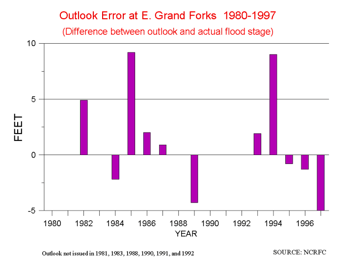
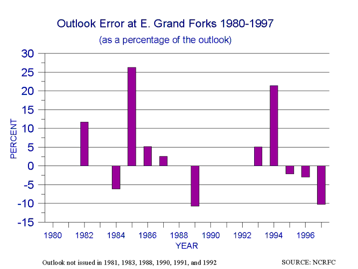
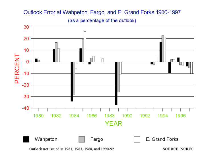
An analysis of the outlooks issued from 1982-1997 for Wahpeton, ND, Fargo, ND, and East Grand Forks, ND shows considerable uncertainty in the crest stage outlooks. At East Grand Forks, the actual crest equaled or exceeded the "normal" level outlook in 6 of the 12 years in which outlooks were issued for this location (Figure 2). The average error ( i.e., absolute value of the difference between the outlook and actual crest stage) at East Grand Forks is about 3.5 feet. At East Grand Forks in 5 of 12 years the "normal" crest outlook was off by more than 10% of the outlook value (Figure 3). The average percentage error in the outlook (as a percent of the outlook) is 11.5%. The 1997 outlook, 5.1 feet less than the actual crest stage, is the third worst (out of 12) in terms of error measured in feet, and the percentage error (10.2%) is 5th worst. But, perhaps more importantly, the percentage error in 1997 was less than the average error from 1980-1997. A similar interpretation results from looking at the outlook errors for each of the three locations along the river from 1980-1997 (Figure 4).
Placing the 1997 outlook into historical context, indicates that the 1997 prediction was worse than average in terms of feet, but perhaps more importantly, better than average in terms of percentage. The forecast error was neither unique or unusual, and in fact, because it was a forecast of a record event, arguably better than those issued in more typical years. Responsibility for the apparent misuse of the outlooks is shared. The NWS failed to communicate effectively the uncertainty of the predictions, and some local decision makers failed to appreciate the uncertain nature of flood forecasting. The result was that actions were taken based on a misinterpretation of what could have been useful information.
Alternative Explanations
There have been several alternative explanations for the miscommunication between the NWS and the flood fighters in Grand Forks and East Grand Forks. Both explanations lay responsibility squarely with the NWS, rather than sharing it with the community. The first claims inadequate technical performance, and the second claims poor communication between government agencies. Underlying these two claims is the notion that a more accurate forecast could have been produced in time for local decision makers to take action. But a close examination of each of these alternative explanations leads one to conclude that they are either simply misinterpretations of the event or supportive of the more general failure to incorporate considerations of uncertainty in the flood forecasting process, including production, communication, and use of information.
"The NWS Blew It"13
A series of articles in the Grand Forks Herald suggested that the NWS simply did a poor job of forecasting the flood (Merx 1997a and b; Paulsen 1997). They state that the NCRFC failed to account in their flood stage forecasts for bridges in the city which could retard the flow, (and thus increase the river's stage) and sandbags and other temporary levees which might affect the flow, These complaints are valid. Indeed, when the NWS Disaster Survey Team announced its preliminary results in July, 1997, it stated that in addition to the bridges, the tremendous volume of water downstream (north) of Grand Forks resulted in a "backwater" effect which served to increase the river stage above what was forecast (Bradbury 1997a).
Most responsibility for the error lies with the simple fact that the river had never before been observed at these levels. Therefore, the hydrological models, which are empirically based, were "flying blind" in the sense that there was no historical basis on which to produce a reliable forecast. This serves to underscore the importance of the uncertainty in the flood stage predictions. At record or near-record stages, uncertainty is compounded by a lack of relevant experience, and it is at these river levels that forecasts matter most.
With regard to the bridges, the NWS ought to have known of their effects on the flood stage. A 1985 U.S. Geological Survey report notes that, based on the 1969 flood, the bridges at Grand Forks "restricted the flow of the water and caused a significant increase in flood elevation" (Miller and Frink 1984, 10). For one particular bridge in downtown Grand Forks, Miller and Frink (1984) report this amount to be about 1 foot, the same amount reported in the findings of the NWS Disaster Survey Team (Bradbury 1997a).
Given that the difference between the outlook and the ultimate crest stage in 1997 at East Grand Forks was consistent with previous differences at that same location, as well as at locations upstream (see previous section), it is a misinterpretation to claim that the NWS "blew it." Furthermore, if the NWS flood predictions had been consistently one or two feet higher, i.e., had they considered the bridges, the outlook and forecasts would still have been considerably less than the actual crest stage. Thus, an analysis of NWS performance returns us to the issue of uncertainty in the flood predictions and how that uncertainty is interpreted by decision makers.
"An $800 Million Miscommunication"14
An article in the Grand Forks Herald on May 4, 1997 suggested that the U.S. Army Corps of Engineers had information in advance of the flood that would have allowed a more accurate prediction of the peak river stage, and that this information was not communicated to the NWS (Paulsen 1997). The article placed responsibility for the damages in the Grand Forks area on the NWS for its failure to communicate with the Corps. A closer look at the events preceding the flood indicate that while communication was less than optimal between the NWS and other federal agencies, including the Corps (as well as with local officials), it is a misinterpretation to place responsibility for the damages on the communication process between government agencies. One official calls the amount of communication during the period of the 1997 flood "a high point" (D. Braatz, personal communication, 1 March 1999). To preview the argument -- it seems clear that even with perfect communication between the agencies the lack of understanding of uncertainty throughout the forecast process would have set the stage for a misled flood fight.
The relation between a river's volume and height is graphically expressed as a "rating curve" which forecasters use to predict how high the river will rise for a given amount of water entering the channel upstream from a particular point. Rating curves are generally based on experience: that is, historical river conditions are used to generate a rating curve for future use. Of course, when a flood is above record levels there is no experience on which to "extend" the rating curve. Hydrologists use a number of accepted methods to extend a rating curve, which can thus result in different predictions for a river's height for the same predicted volume. Therefore, when forecasters work with an extended rating curve it adds to the uncertainty inherent in a prediction based on experience.
At East Grand Forks, the Red River typically experiences an annual average volume of about 5,000 cubic feet per second (cfs). Prior to the 1997 flood, the record observed volume occurred in 1979 at 83,000 cfs. Thus, the rating curve used by the NWS was based on experience only up to that level. Because the various agencies have different needs, i.e., the NWS focuses on reliable predictions, the Corps on engineering studies, and the Federal Emergency Management Agency on flood insurance mapping, they use different rating curves. In the floods of 1997, hindsight showed the Corps rating curve extension to be more accurate at East Grand Forks than was the NWS rating curve at the record flows that were observed.
Is there reason to believe that knowledge of the Corps rating curve would have led to a more accurate river stage forecast in time for improved decisions? The answer is clearly "no." While hindsight is 20-20, as forecasters were predicting the peak flood level, they would have had no reason to believe a Corps rating curve extension over the one used in their hydrological modeling system. It was only in the aftermath of the flood that forecasters became aware of the deficiencies in the standard rating curve extension used at Grand Forks in the NWS hydrological modeling system.15 In a chronology of its decision making released to the public and the press on 14 May 1997, the Corps stated that
the Corps rating curve for grand Forks was not furnished to the NWS because the curve was a draft working tool used in our
ongoing feasibility study for the Grand Forks flood control project to determine maximum top-of-levee elevations.  It was not
intended to be used as a predictive tool in forecasting flood stages during an emergency . . . The Corps had no reason to believe
that their rating curve was more accurate than the official extended rating curve used by the NWS, until after measured flows at
Grand Forks exceeded the 1979 flow . . . which occurred early on the morning of 17 April (U.S. COE 1997).
There is no doubt that NWS officials should have had the Corps rating curve (as well as FEMA's and any others which would be appropriate) well in advance of the flood. While the different rating curves would not necessarily have led to a more accurate crest prediction, discussion between NWS and Corps officials as to the reasons why it differed from the NWS rating curve could have contributed to a better understanding of the uncertainty in the predictions.16
Communication clearly could have been better between the NWS and the Corps prior to and during the flood event.17 The differences in rating curves was in fact not noticed until after the event when a reporter discovered that the two agencies arrived at different crest stage levels for the same discharge. NWS and Corps officials did not recognize the differences in the rating curves before that because the two agencies communicated in terms of the crest stage, rather than discharge. In the future, release of its discharge predictions, in addition to stage predictions, might help those with technical expertise to better identify and quantify the uncertainty in the predictions. In spite of the shortfalls in the inter- and intra-governmental process of communication, the shortfalls in communication experienced during the spring of 1997 cannot be held responsible for the damaging flooding at Grand Forks and East Grand Forks.
With a More Accurate Prediction, Would Grand Forks Have Been Saved?
With a more accurate prediction, some local officials like the Grand Forks city engineer (quoted above from Paulsen 1997) clearly feel that the city could have taken steps in advance to protect areas from flooding. The Corps has an admirable flood fighting track record that would seem to support this contention. Yet others in the community suggested that the community would not have sacrificed parts of the city (e.g., by intentionally flooding low lying areas to increase channel capacity) to protect other parts because of the political ramifications. Thus, it is conceivable that even with a perfect flood outlook months in advance, Grand Forks might not have been saved. While it can never be known with certainty what would have occurred with a more accurate forecast, because local officials did not have information which would allow them to understand the uncertainty inherent in the predictions that they were provided, they were not given the opportunity to choose among possible alternative flood fighting strategies. Similarly, if local residents had better understood the uncertainty of the forecasts, then some might have chosen to move their belongings well before the event. The provision of uncertainty information would have empowered decision makers at all levels.
A broader question is whether or not damages might have been avoided had the community been more "forecast independent" -- that is, less reliant on forecasts through structural or non-structural mitigation policies. Indeed, a city official observed in an interview that if the 1979 flood had led to greater impacts, there might have been fewer residents living close to the river in 1997 and thus fewer structures to protect. In the aftermath of the 1997 flood, residents face difficult decisions about land use and floodplain occupancy. No matter the results of these decisions, because of the geography of the region the Grand Forks community will always be reliant to some degree on forecast information as part of its flood mitigation strategy. There is no bluff on which the city might relocate. Consequently, while longer-term decisions such as land-use planning can significantly reduce the community's vulnerability to floods, it is unlikely that these decisions can completely obviate their reliance on flood forecasts.
Information-Induced Decision Process Pathologies
This analysis of response to flood predictions in Grand Forks and East Grand Forks leads to several conclusions about the role of forecasts in processes of decision:
Because the NWS issued each crest stage prediction as two numbers, local decision makers did not have the information necessary to evaluate the risk they faced under alternative courses of action. Effectively, this put the NWS in a position it should not find itself -- of implicitly deciding what level of risk a local community should face (i.e., in this case a crest stage of 49 feet). In other words, local decision makers did not have reliable information on which to decide whether to pursue a more aggressive (or a more conservative) response. Their response was dictated by the NWS prediction. For local decision makers seeking to use the prediction, this can lead to misjudged risk assessment, overconfidence in forecasts, and ultimately poor decisions about how to fight the flood. A more appropriate process would have provided local decision makers and the public with probabilities of different levels of inundation and information about the limits of predictability. The decision makers could have coupled the prediction information with other relevant information and then decided how they ought to respond. Exactly how this process of communication of uncertainty would be done (e.g., what is communicated to whom, how, etc.) is unclear and requires further investigation and experimentation at the local level.
Some local decision makers in the region want this responsibility, others do not. Many of the decision makers interviewed expressed the following sentiment: "We don't want changes, just give us an accurate forecast that the NWS will stand behind." The local resistance to change is understandable: the effect of providing probabilistic information would result in a shift in responsibility (and accountability) for decision making on the question of "what river height do we prepare for?" from the NWS to the local decision makers. For many local decision makers, this added responsibility is not desired. But more generally, few would argue that such decisions belong at the local level and should not be made by the NWS.
Flood forecasts are an important component of federal flood policy as many decision makers rely on them. The United States government is currently in the process of spending more than $4 billion to "modernize" its National Weather Service, including improvements to its river and flood program (Fread et al. 1995). Such improvements carry with them a promise to "greatly improve the capability of water facility and emergency managers to take timely and effective actions that will significantly mitigate the impact of major floods" (Braatz et al. 1997). To be met, this promise requires that decision makers use forecasts in a manner which results in improved outcomes from society's perspective. As Gilbert White noted in 1939, "a forecast is of no value unless those who receive it are prepared to act promptly and efficiently." Further, a forecast that is "inadequate" -- meaning either mistaken, misleading, or misused -- "may cause more loss than had there been no forecast at all" (White 1939, p.218).
At stake for the forecasting community is the ability to make good on its promise to contribute to societal benefits and thereby secure continued support of the public and its elected representatives. A view held by some -- that forecasters forecast and what others do with the forecasts is their responsibility -- no longer seems tenable. In the environment of U.S. science policy, scientists who demonstrate a clear connection between research improvements and societal outcomes will have an upper hand in the budget process. This means that the forecasting community should assume some responsibility to ensure that their products are used appropriately.
As the NWS moves toward the issuance of probabilistic flood forecasts (Braatz et al. 1997), they must take care to ensure that such forecasts are of use to decision makers. While there is a growing body of experience and theory on the use and misuse of weather and climate forecasts, knowledge of the use and misuse of flood forecasts remains primitive. Four bodies of experience and theory stand out as particularly ripe opportunities to contribute to effective implementation of probabilistic flood forecasts: (1) A comparison of the flood response in 1997 in Fargo to that of Grand Forks yields some interesting hypotheses. (2) The Advanced Hydrological Prediction System of the NWS provides a ready-made laboratory for the prototyping and evaluation of probabilistic forecasts in small-scale settings. More broadly, (3) experiences with hurricane forecasting in the United States and (4) seasonal climate prediction in Australia provide data which may contribute to improved use of flood forecasts.
Flood Response in Fargo, ND, April 1997
The flood fight in Fargo was different in important respects from that in Grand Forks.18 A comparison of the two communities' approaches to flooding might yield some useful information for other communities with flood-related concerns. Such a comparison would likely consider the following two factors:
Fargo largely escaped damages from the 1997 flood. It would be of value to understand how much, if any, of the different outcomes can be attributed to differences in response to the event.
Advanced Hydrological Prediction System
The Advanced Hydrological Prediction System (AHPS), initially implemented by the National Weather Service in the Des Moines River basin beginning in March 1997, provides an opportunity to learn more about how decision makers perceive and use flood forecast information.19 The AHPS is to build on the NWS Modernization and is expected to have the capability to generate probabilistic predictions of river stage levels up to several months in advance. As part of the initial implementation in Des Moines, decision makers in the basin were sent a questionnaire asking about their information needs. The results of this first AHPS implementation need to be closely evaluated from the standpoint of the use of information. If successful, it may provide a model which can be replicated in other basins.
Lessons from Responses to Hurricane Predictions
In 1983 the U.S. National Hurricane Center began to issue hurricane forecasts in terms of the probability of the center of a storm passing within 65 miles of selected locations. Preceding this, hurricane forecasters and emergency managers had expressed concern that if the NWS issued probabilistic information, which was desired by emergency management officials, it would adversely affect public response because of "a belief that the public was largely ignorant about probabilities in general and about the appropriate use of them in particular" (Baker 1995, 137).20 In contrast to this belief, Baker (1995, 146) found that "people are more capable of comprehending and using at least certain types of probability information than is usually noted in the information processing and subjective risk literature."
The use of probabilistic information in the hurricane case suggests that such information might be fruitfully applied in the case of floods. This then begs for a systematic evaluation of the hurricane case so that lessons are learned and mistakes are not repeated in the case of the floods. It is worth noting that in Baker's conclusion he notes that "possibly the most important finding pertaining to hurricane preparedness is that local officials' advice or orders regarding evacuation remain by far the most important element in affecting evacuation, regardless of whether probabilities are included in people's information or not" (pp. 148-149). This adds further support to the notion that responsibility for flood-fight decision making lies at the local level, and not with the NWS.
Australian RAINMAN
Over the past several years, the Australian government developed a decision aid for people (mostly farmers) whose activities are significantly affected by rainfall. The management tool comes in the form of a software package called RAINMAN: Rainfall Information for Better Management. The package is based on historical climate information and provides its user information related to the probability of a certain amount of rain occurring at a particular time for more than 4,000 places in Australia. Such a tool is made possible because Australia's climate has a very strong connection to the El Niño-Southern Oscillation phenomenon. In years when El Niño is in its warm phase (i.e., an El Niño event) parts of Australia are likely to receive less rainfall than in other years, and similarly when El Niño is in its cold phase (a La Niña event), rainfall is more abundant for certain areas.21
The use (or misuse) of the probabilistic information provided by Australian RAINMAN provides a valuable body of experience. In this case, individual decision makers (mostly farmers), are empowered with the information needed to assess the risks that they face on an annual basis. Because the average Australian farmer typically makes almost all of his (her) profits in only 3 out of 10 years (the rest suffering losses or breaking even), it is important to factor climate information into agricultural decisions. Unfortunately, an assessment of the successes of shortfalls of the Australian RAINMAN has yet to be published.22 An evaluation of the effectiveness of this program would provide valuable insight as to the use and misuse of probabilistic weather and climate information more generally.
The damaging flooding in 1997 in the Red River of the North was the outcome of an extreme hydrological event and many decisions made over many years. In the aftermath of the disaster, attention quickly focused on the role that official river stage predictions played in flood fighting decision making. The following five conclusions drawn from the Grand Forks experience have broader significance for the use of river stage predictions.
Flood forecasting has an important role to play in the nation's efforts to reduce its vulnerability to damaging floods. However, as the case of the Red River of the North illustrates, the promise of flood forecasting will be met only if explicit attention is paid to the use and misuse of forecast products.
|
Center for Science and Technology Policy Research University of Colorado/CIRES 1333 Grandview Ave, Campus Box 488 Boulder, Colorado 80309-0488 Tel: 303-735-3940 Fax: 303-492-1149 pielke@colorado.edu |