

 |
 |
 |
 |
notes from the field
These field notes are personal views and do not necessarily reflect the views of Red Cross/Red Crescent Climate Centre
Sierra Gladfelter
Zambia
June 3 - August 23, 2016
Early Warnings for Floods: Formal Interventions vs. Traditional Forms of Relaying Critical Information
August 2016
View photo gallery for more photos from the field by Sierra Gladfelter
Across Zambia, the vast majority of rural residents receive little to no warning in advance of severe inundation.
"Seasonal forecasts provided by the Zambia Meteorological Department (ZMD) are the only form of formal climate and weather information that actually makes it to most rural farmers." |
 This fact is particularly tragic considering that in Southern Province alone, the ZMD has eight automatic weather stations collecting live data daily. Furthermore, while I was told that the ZMD’s national headquarters has the technical capacity to prepare flood forecasts and issue advisories based on precipitation and live river level data collected upstream, its current system of relaying information electronically prevents meaningful lead times from reaching the most at-risk people on the ground who often lack electricity and cellular networks, not to mention working internet connections.
While the agriculture extension officers bear the burden of dissemination and of translating forecasts into local actions, upon receiving flood advisories via ZMD’s listserv, they face their own set of limitations. Besides having rare access to email which is linked to the intermittent cellular network, rapid dissemination is also compromised by the fact that many agriculture extension officers are stationed in rural communities with no other means of transportation than a bicycle. While the ZMD notifies radio stations and news outlets through its formal email list, only a few of these media partners include these forecasts in their broadcasts. Moreover, even these few broadcasts rarely reach the southern bush, where people along the Zambezi River are more likely to pick up air waves from nearby Namibia’s radio stations.
As a result, not one of the residents who I interviewed in communities throughout Kazungula had ever received a formal warning from the ZMD in advance of a major precipitation event. For this reason, my interlocutors informed me, all actions taken in the days and hours leading up to a major flood, such as securing personal property, reinforcing structures, and evacuating to higher land, are guided strictly be early warnings observed in the environment and informal ways of exchanging information between upstream and downstream communities.
"Local communication chains provide an implicit structure for conveying critical information that although imperfect, continues to function as the only early warning system people rely on." |
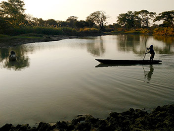
 Since villages are generally situated linearly along tributaries that run into the Zambezi River, those located on the floodplain usually have other villages upstream that they depend on for informal information on upstream precipitation and water levels.
When interviewing stakeholders in Sikaunzwe, Kawewa, Kasaya and Simalaha, I found that all communities were linked through informal communication systems to people upstream who often warned them of impending floods. Depending on the location and reliability of the local cell phone network, some people described receiving this information by cell phone or text. However, more common were warnings provided by people traveling downstream on their way to the main road for trade or travel. As they pass through villages on the way to their destination, such individuals share information about conditions upstream, including when water has reached a certain level. This information is then distributed locally by the village headman and his personal messengers, sometimes with the help of the ZRCS’s Satellite Disaster Management Committees at whatever village meetings, church congregations, or community events are taking place. These venues enable rapid and wide dissemination in places with limited communication infrastructure. In urgent situations, people sometimes use bicycles to go house-to-house, though this form of transportation is difficult in the rainy season when roads and paths are deeply rutted. Depending on the type of precipitation event upstream, these methods of dissemination can be effective. However, in flash flood events they fail to provide adequate lead time.
 The community of Sikaunzwe, for example, situated along the Lingwazee Stream, has been relying on information conveyed from the 52 villages located upstream for more than five years (likely since the MTN cell phone network became reliable enough to make phone calls). A warning from the furthest village, approximately 15-20 kilometers away, can provide up to a two to three-day lead time before floodwaters strike Sikaunzwe. Interestingly, rather than relying on a single individual or instituting a formal structure for disseminating the warning, in this community-initiated early warning system (EWS) any person is free to call their downstream neighbors. Although somewhat disorganized, in some ways, this more nebulous system of responsibility ensures resilience in a place where cellular service is spotty, people’s phones are often switched off or out of balance to make calls, and living off the grid makes charging devices a daily challenge. If a more formalized communication structure were established here, where key individuals were responsible for calling others on a list, such barriers to communication would need to be accounted for so that if one person was not reachable there would be a backup person (or two) who could be notified.
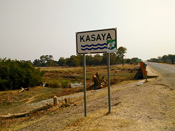 People living along the Kasaya River described a similar system whereby they receive information from several villages strung along the waterway 20-25 kilometers upstream. When residents in Kasaya are warned by Silibani, the furthest village they have contact with, the rest of the community is warned by phone (for those who have them), and announcements are made at church and village meetings. Based on these warnings, people prepare to evacuate with their livestock to the uplands, a distance of 10 kilometers from their permanent residence on the Zambezi floodplains. Although imperfect, and certainly not capable of always providing adequate lead time, these links between upstream and downstream communities are the closest thing to an EWS that currently exists on the ground here.
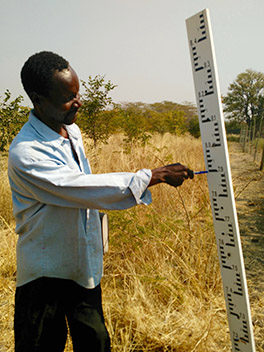
 Although there has been some interest in setting up more formal EWSs at the community level, particularly in the aftermath of the series of devastating floods which struck communities in the Zambezi floodplain in 2006 and 2008, these interventions have largely been ineffective. Many of the programs, initiated by NGOs and humanitarian organizations like the Zambia Red Cross Society and Community Based Natural Resource Management Forum were focused almost exclusively on the dissemination of forecasts from the ZMD. Yet, in stressing the dissemination of information that has never reached the community level, these interventions failed to enhance EWSs by overlooking the limits of the actual data provided by the ZMD, the barriers to relaying it on the ground, and the actions people would be capable of taking even with early warnings. Most significantly, however, these interventions seemed to have completely ignored existing mechanisms for sharing information locally between upstream and downstream communities and instead tried to ‘train’ community members in new techniques focused exclusively on data from the ZMD. The trainings did not involve a component on integrating alternative sources of information (e.g. natural indicators, local knowledge from upstream communities) that might also inform early action and there was no discussion of how this knowledge could be shared in the absence of a reliable cell phone network or radio signal. Perhaps unsurprisingly, since these interventions have phased out, most of the gauges have been damaged or abandoned. The government institutions responsible for assembling locally collected data have turned over and those who were trained to disseminate early warnings have spent the past years more concerned about droughts and their withered crops than inundation. This is what happens when interventions fail to recognize the reality with which people live.
 Based on my reflections, however, there still seem to be a number of ways in which interventions could support more robust EWSs at the community level even in the absence of formal mechanisms. First of all, there are a number of existing gauges and trained readers that are currently providing data to the ZMD, which could also be leveraged to provide localized early warnings to communities downstream using SMS and the existing informal communication structures discussed above. Furthermore, if even simple gauges were added along waterways in the headwaters, it would be possible to establish clear lead times between upstream and downstream locations, which would enable people to predict when and how they would be impacted by floodwaters. Certainly, even such low-tech interventions require time, dedicated staff, and resources. However, if multiple and localized EWSs were established that, rather than telling communities what to do, solicited their input and leveraged the existing ways people anticipate floods and communicate danger, they may be far more likely to stand the test of time.