

 |
 |
 |
 |
notes from the field
These field notes are personal views and do not necessarily reflect the views of Red Cross/Red Crescent Climate Centre
Kanmani Venkateswaran
Lusaka, Zambia
May 11 – August 11
July 8, 2013
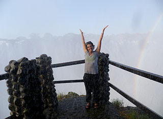
 I’ve been in the field for the past few weeks now, conducting trainings, overseeing data collection, meeting with communities, and so on. Other than this, I have definitely had some time for fun. I got to go to the Victoria Falls – it is more magnificent than pictures can depict. I then proceeded to bungee jump off the Victoria Falls Bridge between Zambia and Zimbabwe which is definitely the most horrifying thing I have ever done in my life. I was unconscious for the majority of the free fall, and only really came to when I was dangling upside-down, over the rapids and crocodiles of the Zambezi.
I also got to (unexpectedly) bushwhack when our Red Cross vehicle got stuck in the flood plain – the truck had to be pulled out by 4 cows. And the coolest thing I got to do was see 3 countries at once. Kazungula is the location of the quadripoint. By standing in one spot in Zambia, I could see Zimbabwe to my left, Botswana in the middle, and Namibia’s Caprivi Strip to the right. It is common to see Zambians take the pontoon boat to Botswana here to go shopping as staples, such as cooking oil and maize meal, are cheaper in Botswana.
As mentioned in my earlier blog post, we are working with communities from the Sesheke and Kazungula districts. In Kazungula, we have been working with Sikaunzwe (pronounced Ska-un-zway) and Kasaya. In Sesheke, we have been working with Situlu and Sikuzu. These communities are predominantly made up of the Lozi tribe. The Lozis are an originally pastoralist community who have been making the transition into agriculture over the past few decades. They have been facing significant problems with floods from the Zambezi river and its tributaries.
 The Red Cross is primarily a volunteer organization. This means that ground operations are mostly conducted by volunteers with coordination and support from the Red Cross National Society and the branch offices. These volunteers are recruited from local communities. The advantage of this is that community members are involved in Red Cross projects, building trust and important partnerships and localizing Red Cross initiatives. In terms of my work, we have been working with volunteers from Sikaunzwe, Kasaya, Situlu and Sikuzu.
Our itinerary in each district was the same. First, we would meet community leaders from each community. The idea of this was to inform community leaders of our goals and gain their support. Community leaders have a great deal of influence in their communities and command a lot of respect. Their endorsement means that community members are more likely to cooperate and participate in our activities.
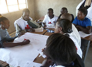
Then, we conducted VCA trainings for the volunteers – one training for the volunteers from Sikaunzwe and Kasaya and another training for the volunteers from Situlu and Sikuzu. These trainings were conducted over 2 days. The goals of the first day of training were to introduce the VCA concept (i.e. what it is, why we are doing it) and to get the volunteers thinking about the vulnerabilities and capacities that exist in their communities. The second day of the training was focused on teaching the volunteers how to use the VCA tools (baseline survey, historical data collection, hazards mapping, transect walks, focus group discussions).
 I learned a lot during these sessions. I learned to talk about my research and goals in a way that was accessible and not bound by jargon. I also learned to think about floods through a different lens. Floods, to me, have always been catastrophic events, resulting in water borne diseases, deaths, poverty, and so on. While floods do result in these things in the communities in Sesheke and Kazungula, they also represent a capacity. For one, the floods bring fish out of the rivers and into submerged land, making it easier for fishermen to fish. Two, the water from floods can be harvested to support these otherwise water deficient communities. It seems surprising that communities in the Zambezi River Basin have water accessibility issues, but the basin is vast and the distances to rivers can be great. One survey respondent reported that the nearest freshwater source was a five hour walk from her village.
At the end of the training sessions, we assigned the volunteers data collection tasks. They were responsible for conducting the baseline surveys, historical data collection and the transect walks. Using volunteers to conduct fieldwork is not without its challenges. The baseline survey, historical data collection, and transect walk sheets were all written in English. The baseline survey and historical data collection were conducted orally by the volunteers and the expectation was that the surveys could generally be conducted in English and orally translated into Lozi when needed. While English is the national language of Zambia, it became quickly evident that English is not widely spoken in poorer communities, especially among the elderly. Having inputted the majority of the baseline survey data, there are indications that the different interviewers understood and translated the questions in different ways. In retrospect, I should have had the surveys translated into Lozi before distributing them.
 During the data collection period, we conducted focus group discussions in each of the communities. These discussions are community meetings and were focused on brainstorming methods of reducing flood risk and increasing disaster preparedness over the long-term. All four communities made a plea for the Red Cross to help with digging dams which could harness flood waters, preventing water from entering fields and homes and providing a water source for communities during the dry season.
A critical element of the discussion was understanding whether or not community-based early warning systems would benefit communities along the Zambezi River. While communities generally welcomed the idea of implementing early warning systems, they seemed somewhat hesitant about using those warnings and taking early action, especially if the early action included some form of evacuation to the upper lands. The upper lands were generally far from their fields and did not have fertile soil on which they could farm during times of flood. In addition, the communities expressed great interest in expanding these early warning systems to include droughts as droughts and floods, together, greatly exacerbate their vulnerabilities.
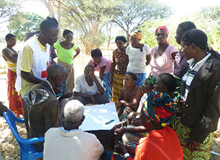
The focus group discussions ended with a mapping session in which community members were divided into groups and asked to draw maps of their communities and indicate, on those maps, areas of flood risk (i.e. vulnerable households, vulnerable fields, submergence zones) and locations of local capacities (i.e. clinics, upper lands, possible shelters). The groups then presented their maps. This has been a really useful exercise. One, because there are no comprehensive maps of these communities. Two, because it provides us with community-wide perceptions of flood risk. And three, because it gives us an idea of what specific areas we need to focus on before, during and after floods.
The majority of data collection is now done. What is left is the historical data collection which volunteers are conducting as I write. As for me, the next few weeks will be focused on collating and analyzing data and report-writing. I do have a mini-field trip lined up over the next week to the Central Province as a part of a ‘Lessons Learned’ meeting conducted by the Zambian Red Cross and the IFRC regarding Red Cross flood response in the Central Province last March. Will write then!
First photo: Group work during the training session for Sikaunzwe and Kasaya volunteers
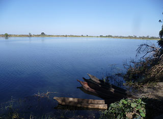
Second photo: The Zambezi River, as seen from Mwandi
Third photo: Hazards mapping session in Sikuzu
Fourth photo: At the Victoria Falls - there was so much spray that I couldn't see the bottom of the falls!